What Is the Coffee Belt—and Why Does Coffee Grow There?
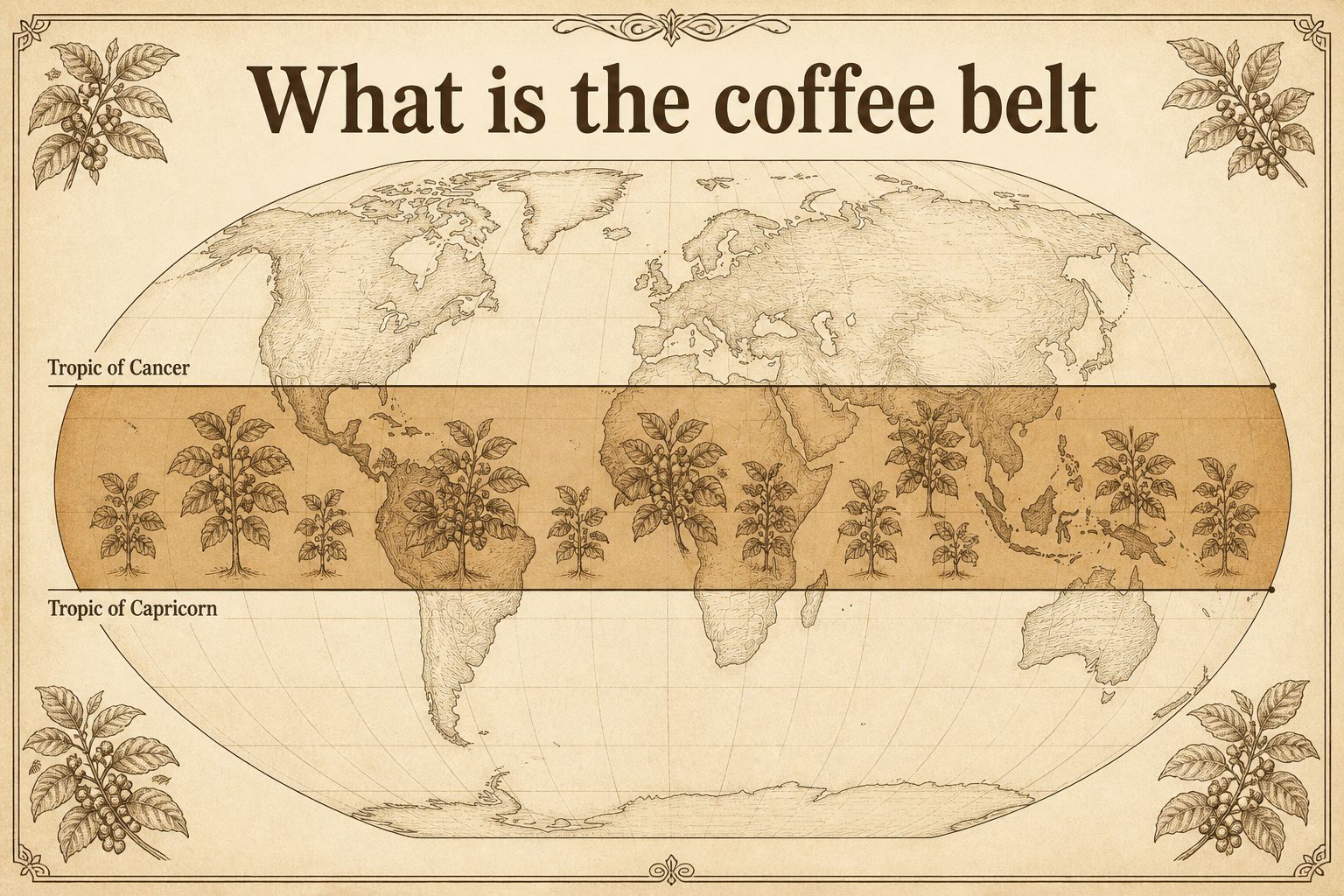
The coffee belt is a teaching name for the tropical region around the equator where most commercial coffee is grown. The usual coffee-belt region runs between the Tropic of Cancer and the Tropic of Capricorn. That sketch is not a border, and being inside it is not enough—oceans, deserts, and hot lowlands sit there too.
Updated: Oct 2, 2026Reviewed by: Content and layout review
What the coffee belt means
When you start learning coffee origins, you often meet a region drawn around the equator called the coffee belt, also known as the bean belt. This article is about where most commercial coffee grows, and why being tropical is not enough.
It is not a country border and not a trade zone. NOAA Climate.gov uses Coffee Belt for a band along the equator, with cultivation in the Americas, the Caribbean, Africa, the Middle East, and Asia. The International Trade Centre’s Coffee Guide puts producing countries geographically between the tropics.
The usual coffee-belt region runs between the Tropic of Cancer and the Tropic of Capricorn, about 23.5° north and south. That is a diagram to get your bearings, not a surveyed line. A 2006 physiology review confines the commercial crop mainly to the tropical region, from about 20–25°N in Hawaii down to 24°S in Brazil, largely because of temperature and humidity.
Which countries are in the coffee belt?
Coffee packaging usually identifies a country or region rather than the coffee belt: Ethiopia, Brazil, Taiwan. The coffee belt provides broad geographic context for these origins, most of which lie in the tropics.
These examples give you a starting point across three regions. They are not a complete country list, and naming a country does not mean coffee grows throughout its territory.
Made with Natural Earth public-domain map data; mobile screens show regional details from the same geometry. Dots are country reference locations, and whole-country shading is only a locator. The tropics are drawn at approximately 23.5° north and south; the band between them is not actual coffee-growing coverage or a test of farm suitability.
Taiwan straddles the Tropic of Cancer at the northern edge of the usual coffee-belt sketch. The line does not put the entire island in one growing environment.
Why coffee mostly grows in the tropics
Coffee grows well in cool-to-warm tropical conditions. NOAA puts arabica (Coffea arabica) at an optimal range of about 18–21°C (64–70°F), found most consistently in tropical uplands. It can tolerate mean annual temperatures up to about 24°C (about 75°F). Lowlands run too hot; higher latitudes bring winters that are too cold.
The same physiology review names frost and drought as the strongest climatic limits inside that zone. Frost can damage or kill trees in southern Brazil and, nearer the equator, at about 2,000 meters and above.
That is also why arabica so often sits on highlands and robusta in hotter, lower ground. For the differences between these species, see arabica and robusta.
Coffee does not grow across the whole belt
Oceans, deserts, and hot lowlands sit inside the same latitudes. The figure is a sketch, not an origin identification map.
The band around the equator crosses a lot of ocean. On land it also includes tropical deserts and hot lowlands where coffee does not grow well, or at all.
ITC’s market hub says around 70 countries produce coffee, and Brazil, Vietnam, Colombia, Indonesia, and Honduras account for about 75% of output. Brazil is the largest producer. Ethiopia holds exceptional arabica diversity.
Being inside the coffee belt does not establish whether a location is suitable for coffee. Temperature, rainfall, elevation, cultivation, and processing also matter.
How latitude and altitude interact
Near the equator, coffee more often needs higher ground to stay cool. This illustrates a general relationship; suitable elevations for an individual farm depend on local conditions.
Inside the same tropical region, lowlands near the equator are hotter. Growers commonly plant arabica at higher elevations to find cooler conditions. Farther from the equator, at higher latitudes, cooler seasons arrive at lower elevations, so a lower hillside can still work.
The Coffee Guide, drawing on World Coffee Research and Christophe Montagnon in 2021, puts that pattern in numbers: near the equator (about 5°N to 5°S), elevations above 1,600 meters are labeled high-grown coffee; beyond about 15° of latitude, plantings above 1,000 meters can count as high-altitude growing. The account also points to growing conditions in Central America and East Africa, where altitude ranges widely. Brazilian varieties are primarily low altitude; Colombian varieties are largely high.
Read the country name alongside elevation, variety, and processing information. Terms such as “tropical” or “high grown” alone cannot establish how a coffee will taste.
Where Taiwan sits on that sketch
The Tropic of Cancer crosses Taiwan at about 23.5°N, leaving parts of the island on either side of the typical coffee belt’s northern edge. Taiwan’s Central Weather Administration describes the south as tropical and the north as subtropical; monsoons, rainfall, and mountain terrain also shape local conditions.
Taiwan produces coffee, although imports supply most of its consumption. See the Taiwan page for local production figures and growing regions.
Common Misconceptions
Is the coffee belt a legal border or a map region?
No. It is a teaching name for the tropical region where most commercial coffee grows. The usual coffee-belt region between the Tropic of Cancer and the Tropic of Capricorn is a sketch, not a cadastral or trade boundary.
Can coffee grow everywhere inside the tropics?
No. The same latitudes include oceans, deserts, and lowlands that are too hot or too dry. ITC notes that around 70 countries produce coffee, and output is concentrated in a handful of them.
Does coffee grow only between 23.5°N and 23.5°S?
That is how the coffee-belt region is commonly drawn, rather than an absolute limit on where coffee can grow. A 2006 physiology review places the commercial crop mainly in the tropical region, roughly from Hawaii at 20–25°N to Brazil at 24°S. Edges still depend on temperature, frost, drought, and elevation.
Why does coffee need higher ground near the equator?
Lowlands near the equator are hotter, so arabica is often grown in cooler upland areas. ITC, citing World Coffee Research, notes that farms near the equator have higher optimal altitudes; farther from the equator, at higher latitudes, a lower hillside can still work. The account also points to growing conditions in Central America and East Africa.
Is Taiwan in the coffee belt?
The Tropic of Cancer crosses Taiwan, so it often sits near the northern edge of the typical coffee belt. Taiwan also produces coffee. See the Taiwan page for production figures, growing regions, and the role of imports.
Natural Earth, 1:110m Admin 0 – Countries: Public-domain map geometry and label reference coordinates for the origin locator. This generalized 1:110m dataset uses Natural Earth's de facto boundary convention; it does not map coffee farms, production volume, or precise legal boundaries.
National Coffee Association, Coffee regions of the world: Groups coffee origins by region, including Guatemala and Costa Rica in Central America, Brazil and Colombia in South America, Ethiopia and Kenya in East Africa, and Indonesia and Vietnam in Asia. These are representative examples, not a complete country list.
Central Weather Administration, Taiwan's Climate: Describes the Tropic of Cancer crossing Taiwan, its tropical south and subtropical north, and the influence of monsoons, mountains, and rainfall on local conditions.
NOAA Climate.gov, Climate & Coffee: Uses Coffee Belt for a band along the equator, with cultivation in the Americas, the Caribbean, Africa, the Middle East, and Asia. Brazil is the largest producer. Arabica's optimal range is about 18–21°C (64–70°F), found most consistently in tropical uplands; it can tolerate mean annual temperatures up to about 24°C (about 75°F). The page also cites arabica as about 70% of world coffee; other sources may use a different share.
International Trade Centre, The Coffee Guide, Fourth Edition, 2021: Producing countries are found geographically between the tropics. Table 4 (WCR and Christophe Montagnon, RD2 Vision, 2021) maps latitude bands to low, medium, and high altitude: farms near the equator have higher optimal altitudes than farms farther north or south. The accompanying figure note says the table is for Central America and East Africa; Brazilian varieties are primarily low altitude, Colombian varieties largely high.